EU provides satellite training for Forestry Administration
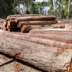
The European Union has begun training Cambodia’s Forestry Administration to use satellite imagery to crack down on deforestation. Members of the EU’s Joint Research Centre have been meeting with forestry officials since September 26, teaching them how to analyse images captured by the EU’s Sentinel-2 satellite and use imaging software to detect signs of forest degradation. The project, which uses open-source software designed by the JRC, is meant to assist Cambodia’s government in reducing carbon emissions released due to deforestation. George Edgar, the EU ambassador to Cambodia, said the high-quality resolution of the satellite images would greatly improve the government’s ability to observe the impacts of illegal logging.

